
District guide
Buying Land in East Delhi
A built-up east bank where the open land is Yamuna floodplain: O-zone limits, disputed tenant farming, the Land Reforms Act, and where to look instead.
3 (Dec 2025)
Sub-divisions
20
Revenue villages listed
6% / 4%
Stamp duty (men / women)
None found
Sourced farmland price series
District land record — East Delhi
Rev. 2026 · Farmland India desk
State
Delhi (National Capital Territory, a Union Territory)
Sub-divisions
3 sub-divisions: Gandhi Nagar · Vishwas Nagar · Patparganj, with 20 revenue villages listed (Revenue Department list, 25 Dec 2025)
Key markets
Built-up east bank, with Yamuna khadar villages at the river edge: Chilla Saroda Khadar · Ghronda Neem Ka Khadar · Gharauli · Kondli · Ghazipur · Karkardooma
Agricultural land
Little that is clearly saleable: the river-edge land lies in the Yamuna floodplain (Zone O), where the Master Plan bars construction and reports describe tenant farming on disputed land (confirm)
Demand anchors
Built-up east bank and the Noida side of the river · Delhi Metro (DMRC route map not opened) · floodplain controls under MPD-2047 (ThePrint/PTI, Aug 2026)
Rail
No main-line station listed in the pages we opened; Delhi Metro, with six Phase 4 corridors named in all (Business Today, Jul 2026)
Size and population
No area or population figure was published for the new boundary in the pages we opened; Census figures for the old district are not used
Pricing unit
₹/acre (agricultural land) · ₹/sq yd (colony plots); no sourced price series for either
Local units
1 acre = 4,840 sq yd = about 4,047 sq m; papers mix acres, sq yd and sq ft, so convert from the revenue record
Land records portal
Delhi Revenue Department (registration and fee page)
Land law is state law. These rules are maintained on the Delhi page and apply to every district within it.
East Delhi — land purchase legal rules
⚠ Three layers of control apply to Delhi farm land at once: the Land Reforms Act, the Master Plan and DDA zoning. Check the land record, the Master Plan zone and the floodplain and Ridge position before you pay anything.
Who can buy agricultural land? The Delhi Land Reforms Act, 1954 (DLR Act) puts its main limits on the seller and on use rather than on the buyer, and we found no bar by domicile in the sources we could open. Section 33 restricts transfers by a landholder that would fragment the holding. The Revenue Department's notice inviting amendment suggestions (undated; comments were due 24 June 2016) called Section 33 outdated and proposed deleting it, but those were proposals. We have not read the current Act text, so ask the sub-registrar or the Revenue Department what applies to the seller's holding before any token payment.
Use of agricultural land (Section 81): Under the DLR Act a landholder who puts agricultural land to non-agricultural use is liable to ejectment, as the same Revenue Department notice describes. A house, event venue or "farmhouse" on land still recorded as agricultural therefore carries legal risk, whatever a broker calls the plot. The notice proposed replacing Sections 81 and 82 with a conversion permission, and we found no evidence that this was enacted.
Fragmentation and title: Many Delhi holdings are small, co-owned, or still in a deceased owner's name. Ask for the current revenue record, the mutation status and proof that the seller can transfer the whole holding.
Master Plan zoning decides what can be built: The Master Plan for Delhi 2047 (MPD-2047) replaces MPD-2021. DDA approved it on 12 August 2026 (Tribune, August 2026), and ThePrint reported it as notified by the Ministry of Housing and Urban Affairs on 20 August 2026. Farmhouse rules are the unsettled part. ThePrint quoted the Housing Minister as saying no farm houses will be allowed in low-density areas, while Outlook Money, August 2026 reported that the draft one-acre norm is absent from the final gazette. Treat the rules as restrictive and still under debate. We could not open the gazette copy, so ask DDA for the zone and permitted use of the plot in writing.
Land pooling: MPD-2047 marks nearly 200 sq km for land pooling and expects about 12 lakh homes from it, according to Outlook Money, August 2026. A village inside a pooling zone may be taken into a DDA-led scheme instead of staying farm land. Ask DDA whether the plot falls in one.
Yamuna floodplain, Ridge and heritage areas: The plan bars concrete structures in the core of the Yamuna O-zone (Business Today, August 2026) and aims to preserve about 180 sq km of floodplain and Ridge (ThePrint, August 2026). About 9,700 ha was declared O-zone under MPD-2021, and the High Court ruled on 26 May 2026 against regularising O-zone colonies (Business Standard, June 2026). The NGT has been monitoring encroachment on the floodplain (NGT order, February 2025). We have not sourced the legal limits around the Ridge, Asola Bhatti or the Mehrauli monuments, so ask DDA, the Forest Department and ASI for written positions on any plot near them. Stay out of the floodplain altogether.
Unauthorised colonies: Delhi opened the SWAGAM portal on 24 April 2026 to register land in 1,511 unauthorised colonies under PM-UDAY, on an as-is-where-is basis, as Outlook Money reported in April 2026. The O-zone and Sainik Farms are excluded from that policy under the High Court order (Business Standard, June 2026). A plot sold as "regularised" needs the regularisation certificate in hand.
NRI & OCI buyers: Under the 2018 FEMA regulations on immovable property (RBI, Regulation 3(a)), NRIs and OCIs cannot buy agricultural land, plantation land or a farm house anywhere in India, Delhi included. They may buy residential or commercial land, subject to zoning.
- Buyer eligibility: confirm
- DLR Act Sec 33: transfer limits
- Sec 81: use ejectment
- MPD-2047 zoning
- Floodplain, Ridge: avoid
- Land pooling zones
- NRI agri: barred (FEMA)
East Delhi — district-specific notes
The Delhi-wide legal framework on our Delhi state page applies to East Delhi in full. The notes below are specific to this district and are not repeated from the state page. Law and policy as read in October 2026; the MPD-2047 gazette copy could not be opened, so confirm that part with a local advocate.
⚠ East Delhi is one of 13 revenue districts notified in late December 2025; the Cabinet approved the change on 11 December (Tribune, Dec 2025) and The Week/PTI reported that it took effect immediately (The Week/PTI, Dec 2025). The Revenue Department list gives it three sub-divisions: Gandhi Nagar (Shakarpur Baramad, Shakarpur Khas, Ghondli, Khureji Khas, Sameshpur Jagir, Seelampur), Vishwas Nagar (Hasanpur, Karkardooma, Ghazipur, Mandawli Fazalpur) and Patparganj (Chilla Saroda Banger, Chilla Saroda Khadar, Dallupura, Gharauli, Ghronda Neem Ka Khadar, Ghronda Neem Ka Bangar, Kondli, Kotla, Khichripur, Nangli Razapur) (Delhi Revenue Department list, 25 Dec 2025). All three sub-divisional offices are listed at the DC-East office, LM Bund Road, Shastri Nagar (Revenue Department sub-divisional offices page). We found no area or population figure for the new boundary.
⚠ Who can buy: the Delhi Land Reforms Act, 1954, in the India Code copy we opened (India Code text), has no residence or domicile bar in the sections we could read, and the copy may not reflect later amendments. Section 1 says the Act does not apply to areas within a municipality, notified area or cantonment, Section 33 stops a bhumidhar from transferring land if that leaves the seller with less than eight standard acres, and Section 42 exposes the buyer to ejectment after a transfer made in breach. In August 2026 the Delhi High Court upheld a Section 81 ejectment over an unauthorised colony on recorded agricultural land in village Goela Khurd and held that such land stays under the Act until a Section 507(a) notification takes it out of the rural area (Delhi High Court, 11 Aug 2026). In East Delhi the river-edge villages are the ones to check, because land there may be recorded as agricultural. Confirm the current text of the Act with a local advocate.
⚠ Yamuna floodplain: Business Standard describes an O-zone of about 9,700 hectares from Wazirabad to Okhla, designated under the Master Plan for Delhi 2021, where the plan bars construction and residential activity, and reports a Delhi High Court order of 26 May 2026 that colonies in the zone are not eligible for regularisation and carry no ownership rights (Business Standard, Jun 2026). Business Today reports that the new plan bans concrete structures in the core O-zone (Business Today, Aug 2026), and ThePrint reports preservation of 180 sq km of Yamuna floodplain and Ridge (ThePrint/PTI, Aug 2026). The Business Standard article does not name East Delhi villages, so we cannot say which listed villages fall inside the zone. Ask DDA in writing for the zone letter and map for every khasra, and treat a parcel inside the O-zone as unbuildable until DDA says otherwise.
⚠ Farming on the floodplain: India Water Portal reports that migrant tenants farm plots leased from private landowners at Patparganj, Mayur Vihar and Chilla Khadar, that the farmers hold no ownership papers and that DDA now claims the same land; it quotes DDA as saying about 7,362.56 hectares of its 9,700-hectare Zone O is encroached, and reports hut demolitions in April 2025 and a clearance of about 20 acres in May 2025 (India Water Portal, Oct 2025). The reports differ on the National Green Tribunal's 2015 ruling: India Water Portal says it banned agricultural activity on the floodplain, while Citizen Matters quotes an expert who says the judgment allowed consumable crops (Citizen Matters, May 2024). A seller who offers floodplain farmland is offering land with an overlapping claim.
⚠ Land pooling: DDA's FAQs apply the scheme to Planning Zones K-I, L, N, P-II, part of J and part of P-I, and exclude unauthorised colonies, Lal Dora areas and land under natural drains and water bodies (DDA FAQs on MPD-2047). We found no East Delhi village named in a pooling sector, so check any such claim with DDA in writing.
⚠ NRIs and OCIs may acquire immovable land or buildings in India other than agricultural land, a farm house or plantation land under Regulation 3(a) of the FEMA acquisition rules (RBI, FEMA 21(R)/2018-RB, Reg 3(a)). Our Delhi state page covers the other limits, such as SC/ST and forest land.
Read the Delhi land buying guide for buyer eligibility, stamp duty and NRI rules.
- Yamuna floodplain (Zone O)
- No sourced price series
- Disputed tenant farming
- Pooling villages not named by DDA
- No residence bar found (confirm)
District overview
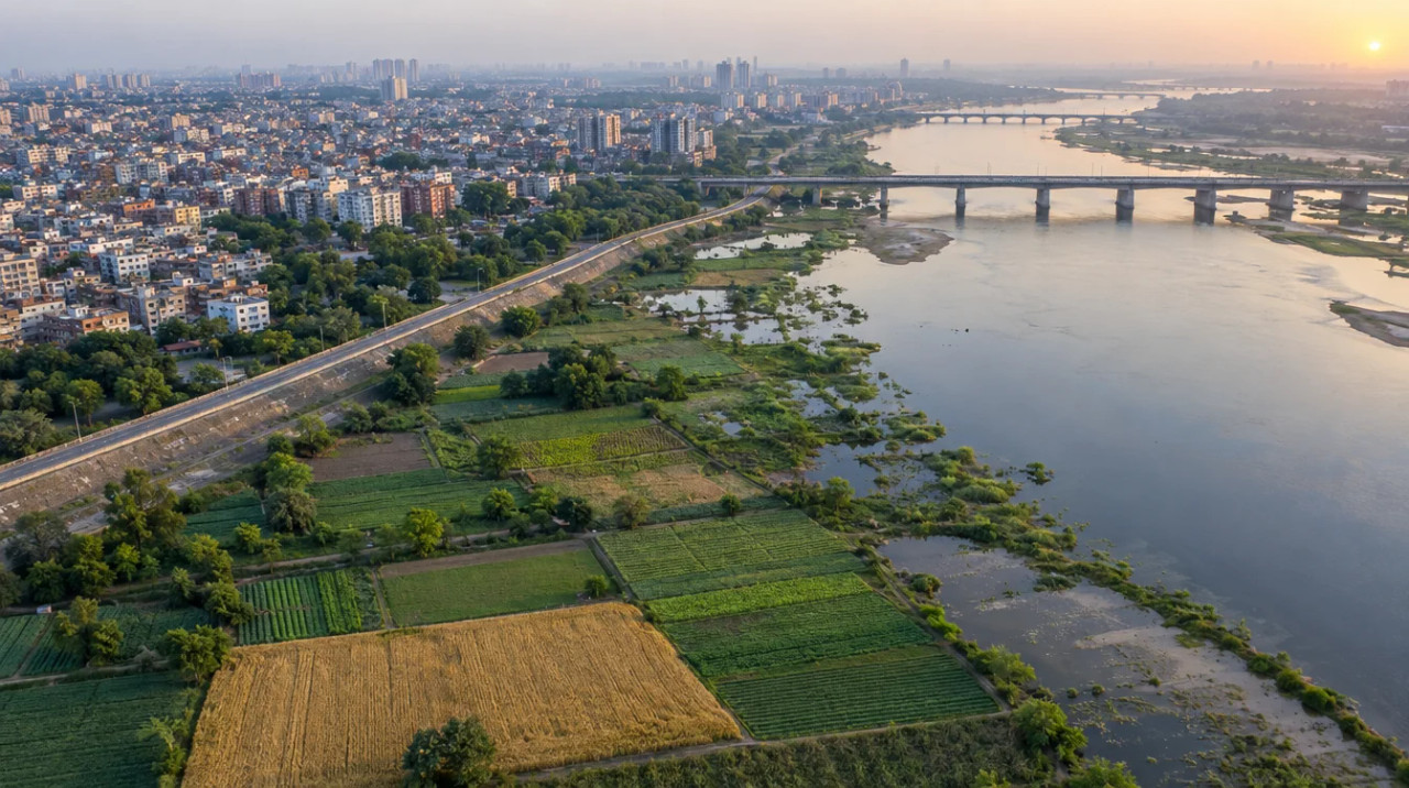
East Delhi — a built-up east bank where the open land is Yamuna floodplain
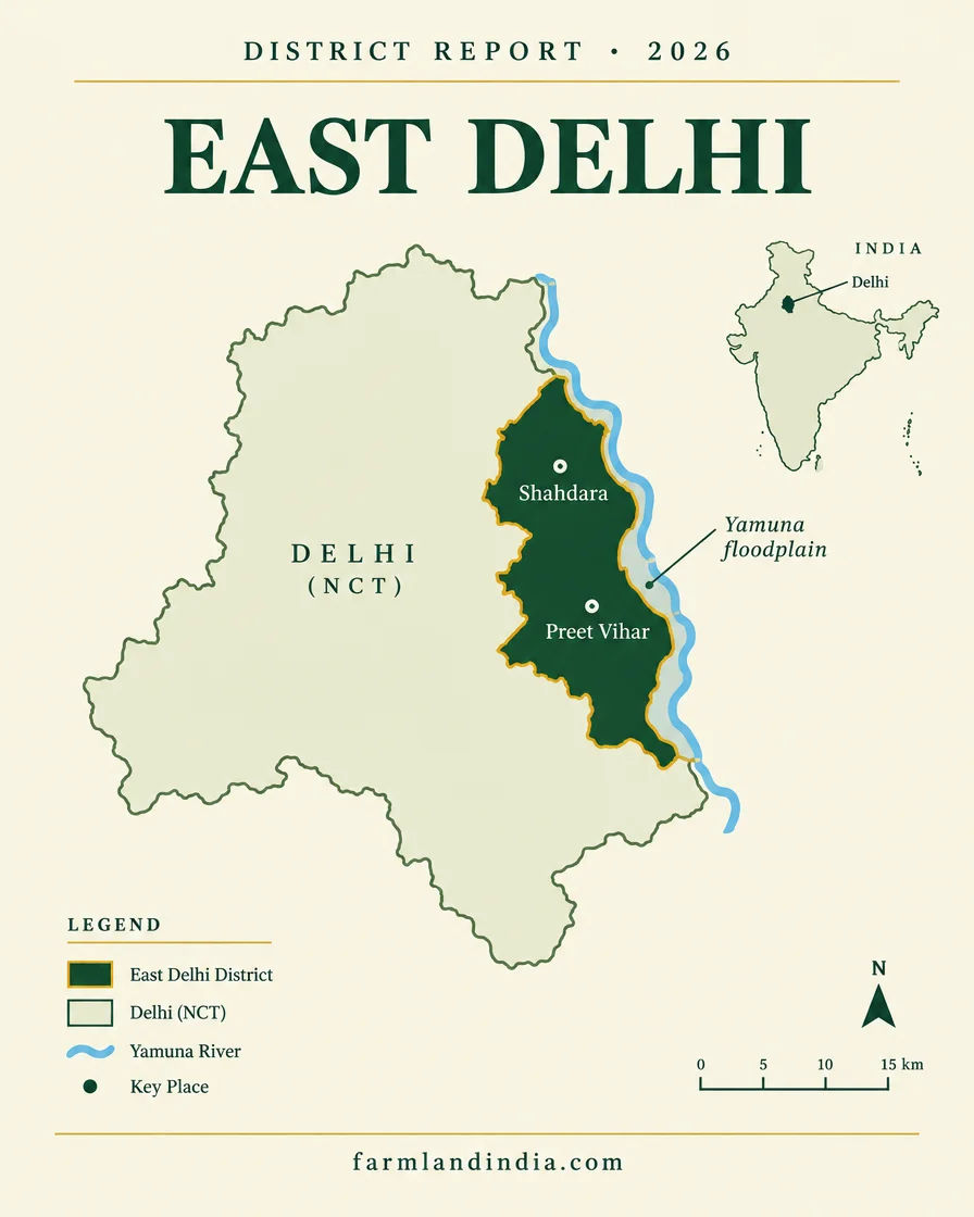
East Delhi is, for a buyer of agricultural land, a cautionary district rather than a farm market, and it is better to say so plainly. It is a built-up district on the east bank of the Yamuna with three sub-divisions and 20 revenue villages listed (Revenue Department). We found no area or population figure for the new boundary, no district crop data and no sourced price for agricultural land.
The Revenue Department list of 25 December 2025 puts the river-edge villages in Patparganj sub-division, among them Chilla Saroda Khadar, Ghronda Neem Ka Khadar, Gharauli, Kondli and Khichripur. Gandhi Nagar carries Shakarpur Baramad, Shakarpur Khas, Ghondli, Khureji Khas, Sameshpur Jagir and Seelampur. Vishwas Nagar carries Hasanpur, Karkardooma, Ghazipur and Mandawli Fazalpur. The Week/PTI reported that the reorganisation took effect immediately (The Week/PTI, Dec 2025).
The open land that remains is mostly the Yamuna floodplain, and that is the problem. Business Standard puts the O-zone at about 9,700 hectares from Wazirabad to Okhla, where the Master Plan bars construction (Business Standard, Jun 2026). PARI described tenant farmers growing melons, vegetables and wheat at Chilla Khadar in 2019 and DDA bulldozing a farm (PARI, Mar 2019). A buyer should read that as a land that is contested and restricted, not as a farmland market with a price.
Where to look instead: for agricultural land inside the capital, read the South West Delhi page (Najafgarh and Matiala sub-divisions) and the Outer North Delhi page (Narela, Bawana and Alipur). For a farmhouse inside Delhi, read the South Delhi page. Across the river, the Ghaziabad page and the Gautam Buddha Nagar page follow Uttar Pradesh law, which differs from Delhi's. East Delhi has no micro-market pages of its own on this site.
- Gandhi Nagar
- Vishwas Nagar
- Patparganj
- Chilla Saroda Khadar
- Gharauli
- Kondli
- Ghazipur
- Yamuna floodplain
Transaction costs
Stamp duty & registration in East Delhi
6%
Stamp duty — male buyer
of the higher of the deal value or the circle rate (Revenue Department)
4%
Stamp duty — female buyer
same basis (Revenue Department)
1%
Registration fee
plus ₹100 pasting fee (Revenue Department)
The Delhi Revenue Department's registration page sets stamp duty on sale, conveyance and gift deeds at 6% for a male buyer and 4% for a female buyer, charged on the consideration or the circle rate, whichever is higher, and a registration fee of 1% on the same basis plus ₹100 (Delhi Revenue Department). The page makes no statement on agricultural land, and we did not find separate rates for NDMC or Cantonment areas. On registration offices, The Week/PTI reported in December 2025 that the existing 22 sub-registrar offices would expand to 39 under a separate notification (The Week/PTI, Dec 2025), so confirm which Sub-Registrar covers the village.
Delhi circle rates are applied by the area and use of the land, and we could not open a notified rate table for East Delhi, so this page gives no per-area figure. For agricultural land, The Realty Today reported in December 2025 a single circle rate of ₹53 lakh per acre last revised in 2008, a draft of up to ₹5 crore per acre in some locations, and a Revenue Department estimate of more than 50,000 acres in over 200 villages still in agricultural use; the draft was not notified at that date (The Realty Today, Dec 2025). Realty Today is a trade outlet and we found no notified 2026 rate, so get any figure in writing from the Sub-Registrar. Conversion or change of land use is a separate approval, not a stamp-duty line.
Know the belt
What is moving prices in East Delhi
Three sub-divisions on the east bank, with river-edge villages inside the floodplain. No listing prices are used; where there is no dated source the notes say so.
Patparganj sub-division (Chilla Saroda Khadar, Ghronda Neem Ka Khadar, Gharauli, Kondli)
No sourced price series
These villages are listed in Patparganj sub-division (Delhi Revenue Department list, 25 Dec 2025); the Khadar villages lie at the river edge. We found no registered-rate, compensation or news price series for land in any of them and use no listing figure.
Check: whether the khasra is inside the O-zone, who holds the record, and whether DDA claims it.
Gandhi Nagar sub-division (Shakarpur, Ghondli, Khureji Khas, Seelampur)
No sourced price series
Six villages are listed here (Delhi Revenue Department list, 25 Dec 2025). We found no price series, and the list says nothing about land use village by village.
Check: the land class on the khatauni and whether the plot is in an approved layout or an unauthorised colony.
Vishwas Nagar sub-division (Hasanpur, Karkardooma, Ghazipur, Mandawli Fazalpur)
No sourced price series
Four villages are listed here (Delhi Revenue Department list, 25 Dec 2025). We found no price series and no sourced description of cultivation in any of them.
Check: the khatauni class, mutation and any DDA or local body notice on the plot.
Floodplain (O-zone) land
Restricted; no sourced price
Business Standard reports that the High Court held O-zone colonies ineligible for regularisation and that the plan bars construction in the zone (Business Standard, Jun 2026). A restricted parcel has no price we can source.
Check: the DDA zone letter and map for the khasra before any advance.
Circle rates to check
₹53 lakh per acre (2008, reported) vs draft up to ₹5 crore
The Realty Today reported in December 2025 a single agricultural rate of ₹53 lakh per acre since 2008 and a draft of up to ₹5 crore per acre, not notified at that date (The Realty Today, Dec 2025). The villages it names as still agricultural include none from East Delhi, though its list is partial.
Check: the current rate for the village with the Sub-Registrar before computing stamp duty.
Units: acre, sq yd, sq m
Delhi papers and sale deeds use acres, sq yd, sq ft and sq m interchangeably. Convert from the revenue record before comparing two documents (1 acre = 4,840 sq yd = about 4,047 sq m). This page quotes agricultural land per acre and built plots per sq yd.
Connectivity
How East Delhi connects — road, rail and air
A Metro-and-road east bank facing the Noida side of the river. Distances are not stated where we could not source them; journey times vary with traffic.
By road
By air
By rail & metro
The practical question for an East Delhi plot is whether it is inside the O-zone, then flood access and the width of the approach road. See the Delhi land rules guide and the neighbouring Gurugram page for the Haryana side. Road status comes from Business Today, Aug 2025, airport status from Noida International Airport, Jun 2026 and Metro status from Business Today, Jul 2026. We did not open DMRC or NHAI pages.
Growth catalysts
Upcoming infrastructure & developments
Status labels reflect sources read in October 2026. Government-announced timelines are not guaranteed; items marked confirm have single or conflicting sources.
01Notified
02Court or enforcement stage
Agriculture & terrain
Terrain, crops & water in East Delhi
A built-up district whose open land is the Yamuna floodplain: flood exposure, Zone O status and overlapping claims matter more than soil.
🌊 Yamuna floodplain (Zone O)
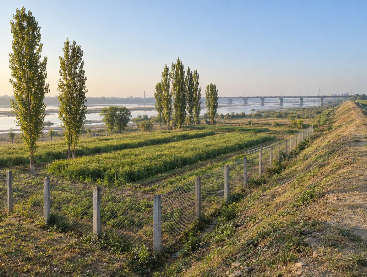
Business Standard describes an O-zone of about 9,700 hectares from Wazirabad to Okhla that absorbs floodwater and recharges groundwater, and where the Master Plan bars construction (Business Standard, Jun 2026). We did not find a village-by-village map of the zone. Flood exposure and Zone O status matter more than soil here.
- Floodplain
- Zone O
- Flood risk
- Khadar
🌱 Tenant farming on disputed land
PARI reported in 2019 that farmers at Chilla Khadar grew musk melons, vegetables, wheat and paddy, irrigated by tube wells because the river is polluted (PARI, Mar 2019). India Water Portal reports in 2025 that the farmers are tenants of private landowners with no ownership documents (India Water Portal, Oct 2025). We have no current acreage or yield figure.
- Chilla Khadar
- Tenant farmers
- Vegetables
- Wheat
🏙️ Built-up east bank
Delhi's net sown area fell from 34,034 hectares in 2000-01 to an estimated 22,300 hectares in 2018-19, and its rural villages from 304 in 1951 to 112 in 2011 (Delhi Economic Survey 2018-19, agriculture chapter). East Delhi's listed village estates away from the river are part of the built-up city. The survey gives no district-wise crop figures.
- Urbanisation
- Village estates
- Declining cultivation
💧 Water & rainfall
Rainfall figures are not quoted here because we found no district series. CGWB's 2024 assessment puts Delhi's stage of groundwater extraction at 100.77%, with 14 of 34 assessment units over-exploited, 13 critical, 2 semi-critical and 5 safe (CGWB, Delhi groundwater assessment 2024). Its district tables flag arsenic above 10 ppb at sporadic locations in East Delhi on the old district boundary; the flags are location exceedances, not district averages. Canal and river water are not sources a buyer should assume. The report gives no block table in the part we could read, so check the latest category for the block and test borewell yield and quality.
📐 Measurement units & market prices
Convert every area to acres or sq m from the revenue record (1 acre = 4,840 sq yd = about 4,047 sq m). We quote no crop prices because we found no sourced district series.
At a glance
East Delhi vs. its neighbours
| District / belt | Land route / price band* | Evidence |
|---|---|---|
| East Delhi — Yamuna khadar villages | No sourced price series | Floodplain land restricted under the Master Plan; claims disputed in news reports (India Water Portal, Oct 2025) |
| South Delhi — Chhatarpur, Sultanpur | No sourced price series | The capital's farmhouse belt, with its own Ridge and sealing checks |
| South West Delhi — Najafgarh | No sourced price series | Named as still agricultural in a Dec 2025 report (The Realty Today, Dec 2025) |
| Ghaziabad and Gautam Buddha Nagar | See the Ghaziabad and Gautam Buddha Nagar pages | Across the Yamuna; separate state rules |
This page quotes no listing prices. Delhi and Haryana follow different land laws; see the Gurugram page and the South West Delhi page, where the farm belt is larger.
Farmland India view
Why investors look at East Delhi
Five reasoned points and an honest note on what this district is and is not.
A restricted river edge, not a farm market
East Delhi is worth reading because it shows what not to buy: land inside the O-zone can be unbuildable and contested. We have no demand data to put a number on any east-bank land.
The rules are tightening, not loosening
The new plan bans concrete structures in the core O-zone and preserves floodplain, and the High Court has refused regularisation to O-zone colonies. That reduces the case for floodplain land, not for land generally.
Scarcity is regulatory
Floodplain protection and built-up density limit what can be developed. Scarcity helps only when the plot is clean: sanctioned, mutated and outside Zone O.
Pooling is not shown for East Delhi
DDA names no East Delhi village in a pooling sector, so pooling returns are not a reason to buy here.
Settle the route before the price
Ask for the khatauni, the DDA zone letter and map, the sanction and the mutation entry before any advance. For agricultural land, start with the outer districts.
Confirm land-record status, zoning, Zone O status and flood history for any parcel; our review is not a title guarantee.
STRAIGHT TALK
Risks & challenges in East Delhi
Read these before shortlisting in East Delhi specifically.
O-zone and floodplain land
A parcel inside the O-zone may not be buildable, saleable with clear title or regularisable. Get the DDA zone letter and map for the khasra, in writing.
Overlapping claims
India Water Portal reports that private landowners lease out plots that DDA also claims (India Water Portal, Oct 2025). A sale deed from one claimant does not bind the other.
Flood and drainage
The Yamuna floods the khadar land, and Business Standard cites the NGT finding that about 2.3 lakh households in the zone lack sewer connections. Water and drainage risk belongs in the price.
Section 81 and rural-land status
Whether a village is still rural for the Delhi Land Reforms Act depends on a Section 507(a) notification, as the Delhi High Court held in August 2026. Using recorded agricultural land for a building can lead to ejectment.
Title and mutation
Tenant cultivation without papers and unmutated inheritance occur in the khadar villages. Check the revenue record, mutation, the Section 33 position and any DDA notice before payment.
Price opacity
We found no sourced price series. The reported agricultural circle rate is ₹53 lakh per acre, with a draft of up to ₹5 crore per acre (Dec 2025 report). Do not budget stamp duty on a number you have not confirmed in writing.
Announced is not delivered
The MPD-2047 gazette copy was not available to us, the July 2026 hearing outcome was not read, and the boundary of the core zone is unconfirmed. Price a plot on what the law allows today.
Who to contact
Local revenue, planning & forest offices
Land-record and mutation matters go through the Sub-Divisional Magistrate and Tehsildar of the sub-division. The Revenue Department lists Gandhi Nagar, Vishwas Nagar and Patparganj at the DC-East office, LM Bund Road, Shastri Nagar (Revenue Department sub-divisional offices page). Sale-deed registration is handled by the Sub-Registrar; the existing 22 sub-registrar offices were due to expand to 39 (The Week/PTI, Dec 2025), so confirm which office covers the village. District-level orders sit with the District Magistrate (East).
Zoning and floodplain questions sit with the Delhi Development Authority, and drainage and river questions with the agencies the court orders name (confirm the current body). Fee schedules and procedures are on the Delhi Revenue Department registration page. Check the khatauni, mutation and encumbrance before paying any token amount.
COMMON QUESTIONS
Frequently asked questions
Everything buyers, NRIs and investors ask before their first reviewed farmland purchase in East Delhi.
Visit full wiki01 of 04
Can I buy farmland on the Yamuna floodplain in East Delhi?
We would not advise it. Business Standard describes an O-zone of about 9,700 hectares where the Master Plan bars construction, and reports a Delhi High Court order of 26 May 2026 refusing regularisation to O-zone colonies. India Water Portal reports overlapping claims by landowners and DDA. Get the DDA zone letter first.
02 of 04
Which areas are in East Delhi now?
Three sub-divisions in the Revenue Department list of 25 December 2025: Gandhi Nagar, Vishwas Nagar and Patparganj, with 20 revenue villages. The river-edge villages include Chilla Saroda Khadar, Ghronda Neem Ka Khadar and Gharauli.
03 of 04
Can I buy agricultural land in East Delhi?
The India Code text of the Delhi Land Reforms Act, 1954 has no residence bar in the sections we could read. Section 33 limits a sale that would leave the seller under eight standard acres, and in August 2026 the Delhi High Court upheld a Section 81 ejectment for non-farm use. Confirm the current Act and the khatauni before paying.
04 of 04
Where should I look for farmland near East Delhi?
A December 2025 report on the draft circle-rate revision names villages in Najafgarh (South West Delhi) and on the Narela side of Outer North Delhi among those still in agricultural use. Across the Yamuna, Uttar Pradesh follows different land rules.
Ready to look at what is available?
Browse reviewed listingsTransparency
Sources and references
Law and courts
- Delhi Land Reforms Act, 1954 (Sections 1, 33, 42), India Code copy, opened October 2026
- Delhi High Court, LPA 34/2024, judgment of 11 Aug 2026 (Section 81, Section 507(a) notification)
- FEMA 21(R)/2018-RB, acquisition of immovable land by NRIs and OCIs, Regulation 3(a), Reserve Bank of India
Government
- Delhi Revenue Department, list of districts, sub-divisions and villages, 25 Dec 2025
- Delhi Revenue Department, sub-divisional offices page, opened October 2026
- Registration page, Delhi Revenue Department: stamp duty and fees
- FAQs on MPD-2047, Delhi Development Authority (pooling zones, redevelopment, heritage areas)
- Economic Survey of Delhi 2018-19, chapter 10 Agriculture, Planning Department
- Dynamic Ground Water Resources of Delhi 2024, Central Ground Water Board
- Noida International Airport, press release, 15 Jun 2026
News
- National capital gets two new districts, The Tribune, 12 Dec 2025
- Delhi now has 13 districts, The Week/PTI, 26 Dec 2025
- MPD 2047 unveiled, ThePrint/PTI, 20 Aug 2026
- Delhi Master Plan 2047 gets DDA nod, Business Today, 13 Aug 2026
- Delhi O-zone: why homes on Yamuna floodplain face uncertainty, Business Standard, 26 Jun 2026
Further reading
- Who owns the Yamuna floodplain: migrant farmers, landlords or the DDA, India Water Portal, 31 Oct 2025
- The trials of being an urban farmer in Delhi's Yamuna floodplains, Citizen Matters, 2 May 2024
- They say there are no farmers in Delhi, People's Archive of Rural India, 12 Mar 2019
- Delhi plans major revision of agricultural land circle rates, The Realty Today, 19 Dec 2025
- Delhi Master Plan 2047 notified, Outlook Money, 21 Aug 2026
- Delhi Metro's biggest expansion, Business Today, 24 Jul 2026
- Noida to Delhi airport in 20 minutes, Business Today, 16 Aug 2025
- Master Plan 2047 protects Lutyens, walled city, Civil Lines, NewsBytes, 20 Aug 2026
Data-currency note: the district map reflects the notification of 25 December 2025 and may change; planning, court and Metro statuses were read in October 2026 and change quickly. Where an official page did not open for us (the MPD-2047 gazette copy, DMRC and NHAI pages), we say so in the text. This is a general guide, not legal advice. Report inaccuracies to wiki@farmlandindia.com.
For developers
Ready to explore East Delhi farmland?
Browse reviewed projects and individual land parcels across East Delhi — or if you own land here, list it with platform review and reach serious buyers.